Hello readers! This week, I’m presenting the first map for the Highmoor series, covering the places visited in the first book. I’m also realising that I’ve made my life difficult by naming the book series after a location, because although this map covers the places visited in the book Highmoor, it is not just a map of the country of Highmoor within said book. In fact, it only covers southern Highmoor, and the largest area is taken up by Nettlewick.
On this note, I’ll give a minor spoiler warning: I’m about to describe the nations mentioned in the first book. There won’t be any plot spoilers other than naming some locations – but I’ll throw out a warning anyway.
(Oh, and in case you missed it, book two launched last week! Find it here on Amazon.)
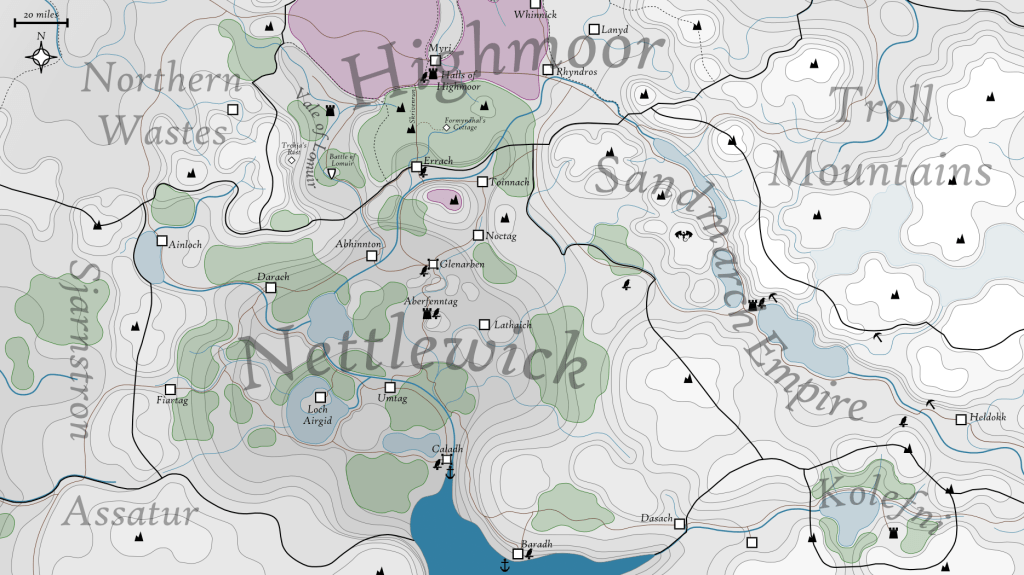
Key:
- White squares are major settlements – either large villages or towns.
- Big white squares with corners are cities.
- Castle icons represent castles and fortresses, or heavily fortified cities.
- Small white diamonds show locations important for the book, but relatively unimportant to the residents of this fantasy world.
- The jagged icons are important mountain peaks.
- Brown lines are major roads and trade routes.
- Black lines are borders: solid ones are international, and dashed ones are internal.
Some fictional history and geopolitics…
The map above contains all the places visited in the first book, and their immediate surroundings. We see the Highmoor forest, where the book begins, and the country of Nettlewick, where a large part of the story takes place.
Highmoor is a sparsely populated country on the upland moors to the northwest of the Troll Mountains. The border with Nettlewick follows the edge of the moorland plateau, where major rivers flow south from the forest and from the Vale of Lomuir. Highmoor is ruled by seven lords from seven families of wizards. Their magical abilities are believed to be a gift from Trekja, their guardian spirit, and for centuries they have defended Highmoor from the witches of the Northern Wastes. The country is further divided into regions managed by barons, who collect taxes and uphold the law within their territory. One of these territories is the Vale of Lomuir, which remains overrun by witches despite many attempts to reclaim it.
Nettlewick is a low-lying nation of lakes and forests to the south of Highmoor, bounded by mountain ranges on all sides. It is more densely populated than its moorland neighbour, with larger, richer cities such as Glenarben and Caladh. Its wealth arises from its fertile farmland, from its close ties with the neighbouring Sandmarch Empire, and from the southern ports that allow trade across the sea to more distant nations.
The Sandmarch Empire is the largest nation in the world, but its bulk lies outside the bounds of this map. The empire acquired the pass through the Troll Mountains relatively recently, in order to take control of the east-west trade routes. This mountain region is sparsely populated, and the route becomes impassable in winter. Centuries ago, this area was inhabited by dwarves, who battled the harsh conditions to mine ore from the heart of the world. However, these mines were abandoned long ago, and the only inhabitants that remain there are dragons and trolls.
The Troll Mountains form the inhospitable core of the world. They are so tall that their peaks are never free from snow and cloud, and only goblins and dwarves have ever managed to settle there, to access the rare minerals that lurk beneath the peaks. Even then, these settlements were short lived. As the name suggests, the only creatures that survive in this region are trolls, and they are very rarely seen. The conditions are so poor that even dragons tend to avoid flying over the highest peaks, meaning that very little is known about the trolls and how they survive.
Kolefni is a tiny nation hidden in a secluded mountain valley, south of the Troll Mountains. This is an elvish kingdom, separated from the larger elvish nations in the east by ideology as well as distance. The elves here worship Trekja, the same guardian spirit as in Highmoor, and they take great pride in their fighting prowess. They are a rich nation, and their wealth is largely a result of mercenary work. There are always groups of skilled Kolefni warriors scattered across the world, helping to settle various disputes.
Assatur is the largest dwarvish nation, although the high plateau that separates it from Nettlewick is very sparsely populated. The dwarves are friendly with all their neighbours besides the goblins, with whom they have feuded for centuries. However, their border with the goblin nation of Sjarnstron has been peaceful for several generations. Most of the goblins there reside closer to the coast, and there is very little trade into Nettlewick.
What next?
For those of you that read Highmoor and wanted a map, I hope this lived up to your expectations! The next step is for me to create a map that covers the journey in book two, Sylvre, which released last week (see the launch post here). My eventual aim is to have a map of the whole world available on this site, and perhaps in book form on Amazon. I hope this post was enlightening, and if you have any questions, feel free to comment and ask.
Discover more from C. W. Clayton
Subscribe to get the latest posts sent to your email.
