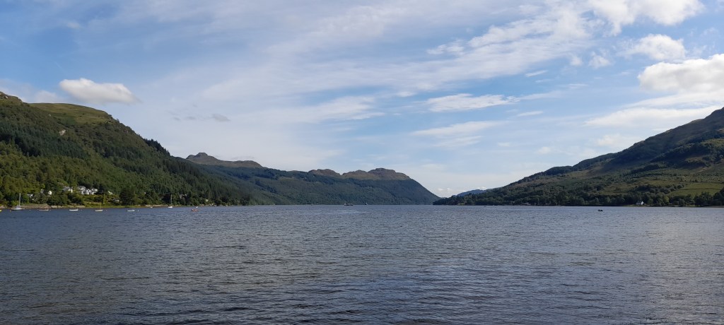
Hello readers! Last week I went on holiday to a fjordy-looking Scottish sea loch to the northwest of Glasgow. Loch Goil is long, deep, and narrow, and is walled in by steep mountains with rocky peaks and forested slopes. The valley sides are so sheer that civilisation has struggled to find a foothold, and the only traces of humanity are a lonely 14th century castle, an MOD compound with conspicuously high fences, and a few scattered cottages of the second-home variety.
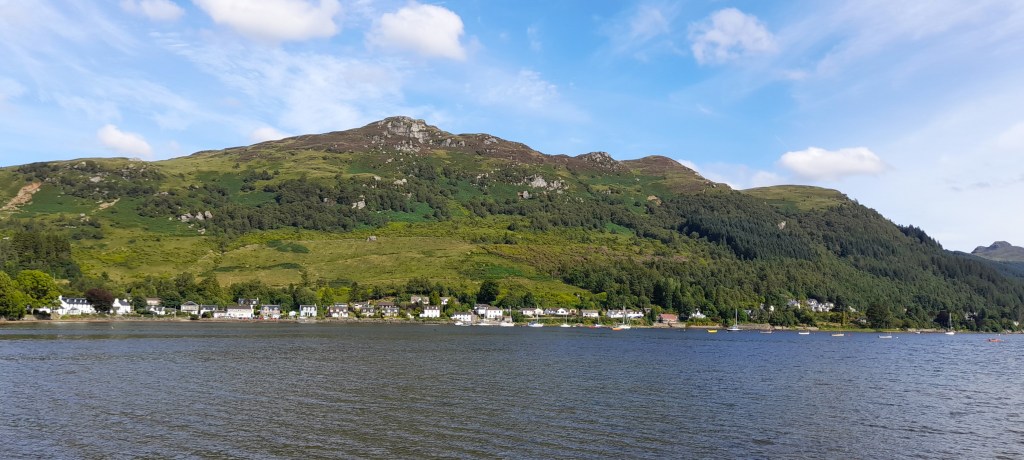
At the head of the valley is the village of Lochgoilhead, home to a few hundred residents and a few hundred more holiday makers. It is a peaceful place, cut off from the world, and if you view it from just the right angle, you’ll feel as if you’ve gone back in time by at least 50 years – a feeling which will only grow as you discover the lack of phone signal and absence of vegetarian dining options.
Getting to Loch Goil
The trip to Lochgoilhead is reasonably straightforward. As with all forays into the northwest of Scotland, the journey begins with a slow crawl through Glasgow and across the Erskine Bridge, providing ample time for the inevitable discussion regarding the towering height of the bridge’s barriers (an uplifting start to any holiday). You then join the tourist convoy of thistle-emblazoned buses, smoke-belching campervans and overladen Kia Picantos winding their way up the banks of Loch Lomond. The lake is pretty when you catch a glimpse of it. Most of the time your attention is fixed on the kayaks strapped to the roof-rack of the car ahead, one wobble away from a six-vehicle pile-up.
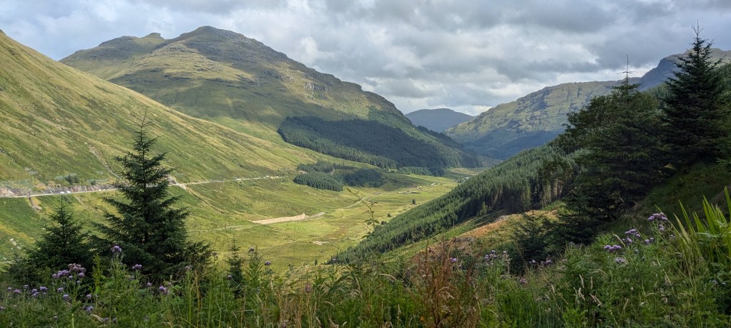
At Tarbet, the convoy is divided. You’ll follow the western branch towards the end of Loch Long, then head up into the mountains via Glen Croe. This is where the landscape suddenly turns wild. There are some very impressive mountains around here, and some very impressive nets trying to stop the mountains from falling onto the road. You’ll reach a viewpoint called “Rest and be thankful” (named by soldiers who had to march up here on the old military road), at which point you’ll turn south into Gleann Mor. The OS Map denotes this road with dashed lines, as if the map makers weren’t fully confident that the road would still exist after publication.
Follow the B828 (yes, it’s a B-road) down Gleann Mor and you’ll find the River Goil. From here, the road leads south to Loch Goil, then no further. You have reached the end of civilisation. The nearest Greggs is 32 miles away.
Things you can do in Lochgoilhead:
Having arrived in Lochgoilhead, we parked the car and didn’t touch it again for a week. Our days were spent wandering into the hills and floating on the loch, and thankfully, the weather was spectacular for the whole time we were there. Much to my surprise, we saw hardly anyone else out and about. The hundreds of tourists in the holiday park seemed content to remain in the confines of their compound, enjoying the great outdoors from the sterile safety of the golf course.
If you aren’t willing to explore the mountains or forests, or if you are unlucky enough to be faced with howling wind and driving rain, then there isn’t an awful lot to do in Lochgoilhead. Make sure you bring enough supplies to last the week, because the post office and the tiny Nisa at the holiday park have only a limited selection between them (especially when it comes to fruit, my god). There is a single pub that does reasonably priced drinks and overpriced food, and a sort of half-pub-half-pizza-restaurant who served us a pint of coke by emptying 1.7 cans into a pint glass. If this sort of whimsy can keep you entertained for a week, then Lochgoilhead is definitely the place for you.
Things you can’t do in Lochgoilhead:
Get a Greggs.
Some very cool, very old rocks
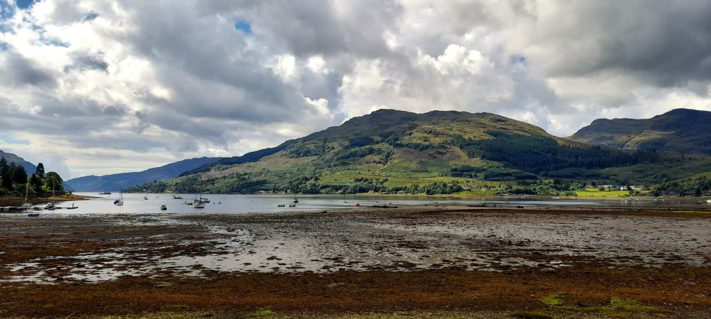
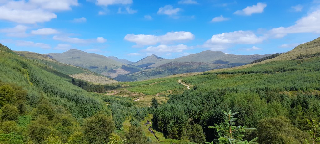
There are some very big mountains around Loch Goil, and they rise straight up out of the sea without any pesky hills getting in the way. Ben Donich to the north is 847 m, while Beinn Lochain and Beinn Bheula to the west are 703 m and 779 m respectively. These mountains are part of the “Arrochar Alps” – a group of summits in the larger Grampian range which have their own distinct character.
The Arrochar Alps are made from schist, a resistant metamorphic rock with a striking appearance. Pick up a piece and you’ll see that it consists of thousands of thin layers, all crumpled and distorted into beautiful, wavelike patterns. The rocks on the hillsides have a mesmerising shine when caught in the sun, which is caused by the reflective mica crystals that have aligned within the layers.
The crumpled and crystalline appearance of the schist is a result of huge pressures deep within the Earth’s crust. These rocks were originally laid down as sandstone and mudstone over 500 million years ago, when Scotland and England existed on different continents. Then, around 450 million years ago, England and Scotland collided, creating a huge mountain chain which stretched from modern-day Norway to Cananda. The mudstones were heated and squashed, and they remained deep underground for millions of years, in which time Scotland and Canada became separated by the Atlantic. Loch Goil was eroded by glaciers only tens of thousands of years ago, which means that these mountains and valleys are nothing but a fleeting moment in the lifetime of the schist.
If you’re looking for activities in Loch Goil, I would highly recommend taking a long walk and finding a nice rock. You can then sit and stare at this rock for some time, pondering the simultaneous significance and insignificance of your own existence. It’s great fun.
Lochgoilhead facts:
While on holiday, I wondered if Lochgoilhead had any interesting history. Apparently, people have lived here since the Stone Age, but nothing major has ever happened – no big battles or cultural breakthroughs. The one exception is in 1976, when Loch Goil broke the record for the largest haddock ever caught in Scotland. A thrilling day for the village, no doubt, as they hurried to find a deep fat fryer big enough. And this summit of human achievement has yet to be surpassed.
I then discovered the section of Lochgoilhead’s Wiki page titled “The Lochgoilhead Hum” – which instantly had me hooked like a giant haddock. Apparently, residents have been complaining about a mysterious humming sound, which started around ten years ago. The village was subsequently added to the “world hum database”, a fascinating project which rides the line between citizen science and conspiracy theory. This concept held my attention for way too long. Did you know that there’s a “big hum” which can be heard all over the world? Sadly, only the chosen few can detect it. But if you strain your ears for long enough, you can start to feel the madness trickling in.
However, the Lochgoilhead hum isn’t just another elusive, water-dwelling myth to support the Scottish tourism industry. This hum can actually be measured. It is very loud, but very low frequency, so humans usually can’t hear it. And, in a twist that nobody saw coming, the sound appears to originate from the MOD’s “Noise Range”, a floating lab in the middle of the loch specialising in acoustic tests. Obviously, the military don’t want to explain exactly what they’re up to, but given the proximity to Faslane, this hum carries the telltale whiff of Subby McSubface. Either that or they’re trying to locate the next biggest haddock.
Boat trip
On one of the days we hired a motor boat for the afternoon and went out onto the loch. I saw oyster catchers, black headed gulls, gannets, herons and cormorants, as well as hundreds of herring gulls. One bird followed us for a couple of miles, hovering just above our boat. Presumably it was hoping that we might throw some food overboard, but this seems like an energy-intensive strategy when it could have been raiding bins in Glasgow. Perhaps it was only trying to intimidate us, in which case it succeeded.
We also saw a seal colony on the western shore of Loch Goil. Unfortunately, the majestic blubber-meisters were too far away for decent photos, so you’ll just have to imagine a group of brown and grey lumps lying on a brown and grey beach. We did get a good view of Carrick Castle, however, and of the giant oil refinery in Loch Long. You can’t say that the scenery lacks variety.
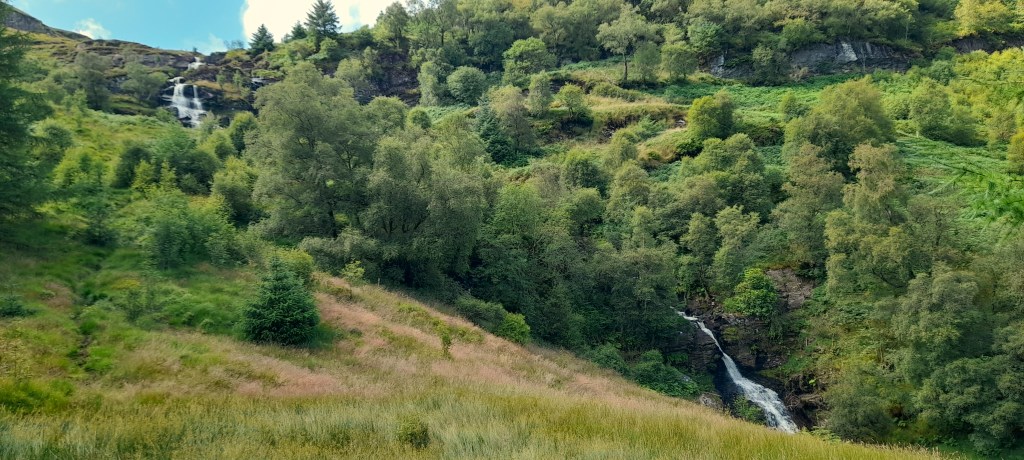
Walks and waterfalls
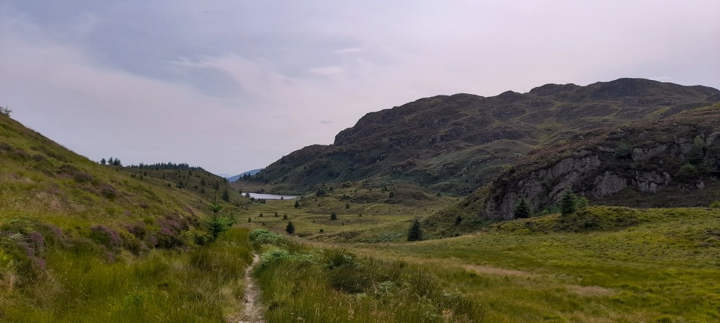
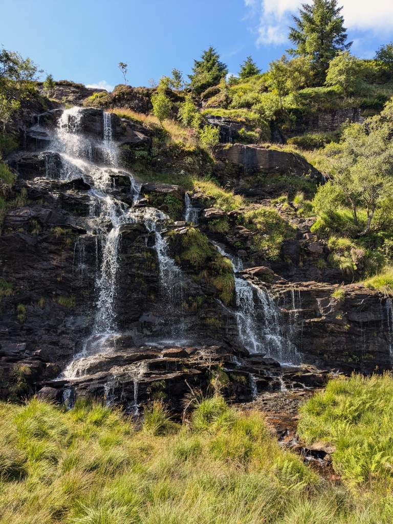
Loch Goil is fed by hundreds of waterfalls, most of which were running fairly low throughout the hot and sunny weather of my visit. On the east side of the loch are the Donich Falls, and there are plenty of other, smaller waterfalls heading south along Duke’s Pass towards Corran Lochan. However, the most impressive waterfall is in the Sruth Ban valley, to the west of Lochgoilhead. The views from here, looking back towards the mountains around Ben Donich, are spectacular.
It is worth noting that although there are plenty of walks around Lochgoilhead, it is very difficult to plan circular routes. This is due to a lack of paths, especially up to the summits. While I’m sure it is possible to reach these places with determination and appropriate footwear, hiking in the Scottish highlands is a world away from the friendly footpaths of English national parks. The OS Map is so barren that it might as well say “here be dragons”.
The main reason for this disparity is that Scotland doesn’t have public footpaths in the same way that England does. In Scotland, ramblers have the right to use any route, so there is no need to differentiate tracks from paths from bridleways, which makes the assortment of dotted green lines that we use in England utterly redundant. Instead, Scotland has nationally recognised “core paths”, which are only sometimes shown on OS maps. Most paths around Loch Goil are tracks that have been built for machinery to access the pine plantations.
The Cowal Way is a major path that goes through Lochgoilhead, and this was the route I took up to the Sruth Ban waterfall. However, it was too overgrown and rugged for some members of my group – a far cry from the dusty motorways that have been scoured by thousands of feet into the Lake District fells. In many ways, I prefer the rugged hillsides and the lack of people in the Scottish highlands, but the entry requirements to enjoy this landscape are so much higher. You need proper equipment, and you need some experience – but if you have these things, you can wander into the most beautiful wilderness and have it all to yourself.
In summary…
I enjoyed my time in Lochgoilhead. It is a very sleepy place, and despite being less than an hour from Glasgow, you feel as if you have made it to the edge of the world. This is a village kept afloat by tourism (and a little bit of post-glacial isostatic rebound), but you wouldn’t know it from the tiny number of people exploring the mountains. Loch Goil is calm and beautiful, and it is a fantastic place to go for a bit of peace and quiet – unless you’re one of the unlucky few who can hear the hum.
Happy reading, and have a lovely week!
Discover more from C. W. Clayton
Subscribe to get the latest posts sent to your email.

One thought on “Clayton goes to Loch Goil”