Hello readers! Last weekend I was in North Wales with some old friends from university, and we finally decided to climb Yr Wyddfa, the highest mountain in Wales. We meet in North Wales every autumn, and although this hike had been in our sights for years, we had always been deterred by miserable weather. It was therefore something of a surprise when we arrived in Wales under a pale blue sky, with a cool breeze and dazzling sunshine. We couldn’t believe our luck. This was the first time that our plans had not fizzled out under biblical rain, and Yr Wyddfa was finally within reach.
Some geographical context…
Yr Wyddfa is the Welsh name for Snowdon, the highest peak in the Snowdonia mountain range. Standing at 1085 m, it is not only the tallest mountain in Wales, but the tallest mountain in the British Isles outside Scotland. The summit is the busiest in the UK, partly because there is a train that runs all the way up there from the town of Llanberis.
It is not just the height of Yr Wyddfa that makes it special but its prominence. There are no other large mountains nearby to impede the view, so on a good day, visitors can see all the way to Scotland, and even to Ireland. I grew up on the doorstep of the Lake District, and I can recall a handful of fine days when I looked south from the top of a mountain to see Yr Wyddfa in the far distance. Now, finally, I had the chance to do the opposite: to stand at its summit and look back north.
Careful planning, woeful underestimation
This hike was not a spur-of-the-moment decision. It had been planned over several months, and documented in a detailed list of locations, timings, transport, and necessary kit, which was distributed to everyone in the group. Our dedication might seem overboard, but after minor mishaps on smaller walks in previous years, we weren’t taking chances. We woke up at dawn, consumed an ungodly volume of scrambled eggs, then crammed ourselves into two cars and set off into the mountains.
At first, everything seemed to be going to plan. Each member of our group was a seasoned fell-walker, and although most of us are more of a salt-and-pepper variety than ras-el-hanout, we considered Yr Wyddfa to be well within our capabilities. The route we had chosen was simple and obvious, and the weather was glorious. The tracks we would follow are walked by tens of thousands of people every year – so what could possibly go wrong? Most of us are familiar with the Lake District, and some of us had even climbed Yr Wyddfa before. We thought we knew what to expect. And we did, in terms of the physical demands of hiking.
However, our confidence started to waver as we drove further into the hills. It wasn’t nine o’clock yet, but already there were hundreds of cars pulled up at the roadside. Every lay-by was crammed. The Pen-y-Pass car park, which has recently adopted a reservation-only policy, was almost full by the time we got there. Only one free space remained in the vicinity, and so our group was forced to split. Half of us had to drive down to the pay-and-display car park Nant Peris, a few miles away, and even this was nearing capacity by the time we got there. We joined the crowd waiting at the bus stop, then piled onto the double-decker that would take us back to Pen-y-Pass.
People. Lots of people.
Never in my life have I seen such a desolate place looking so busy. We were surrounded by sheer slopes and blocky screes, in an ice-carved valley too wild for farming, and here I was staring at haggard, lifeless cliffs through the dust-speckled windows of a double-decker bus. I have never felt so incongruous in the British countryside. And the bus sounded like it shared my sentiment as it screeched and whined its way up the hill, too far from its city comfort zone. However, the choice of vehicle wasn’t some mistake on the council’s part; the second floor was necessary. This bus hadn’t hit capacity, but it was more than half-full, and the one that had arrived 20 minutes earlier had been busier still.
When we arrived at the Pen-y-Pass visitor centre, we were met with crowds of people. The pre-booked car park was full, another bus was already unloading, and several cars were dropping off passengers. The place had the ambience of a railway station at rush hour, complete with queues for the female toilets – although the mood was one of excitement rather than irritation. My friends and I were astounded at the size of the crowds, but most people seemed unphased by the turnout. I can only assume that they had seen all this before, or that they were somehow oblivious to the madness.
A bit of breathing room
We set off as fast as possible, keen to break free from the crowds. Our planned route was vaguely circular: up the Miners’ Track in the base of the valley, past Llyn Llydaw to Glaslyn, then up to the summit, before retracing our steps back down to the Pyg Track, and following this back to Pen-y-Pass along the side of the valley. It was a very simple walk, avoiding the more technical and demanding ridges of Y Lliwedd to the south, or Crib Goch to the north.
The Miners’ Track is wide and gravelled, with barely an incline, and the crowds around us soon dispersed. It was still relatively early in the morning, and we felt as if most people were either behind us, yet to set off, or were following our route in reverse, placing them out of sight on the Pyg Track. It was a beautiful morning; the southern side of the valley was still trapped in shadow, and the peaks were ensnared in drifting silver clouds. Crib Goch emerged from the mist soon after we set off, and we spotted several people creeping their way along the knife-edge ridge, little more than tiny specks caught between the red rock and pale sky.
The Snowdon mines
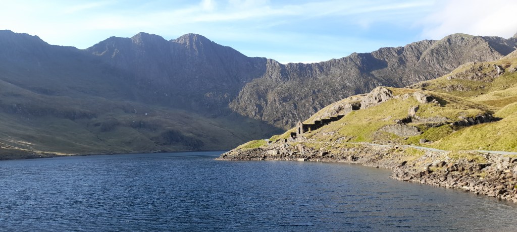
The northern shore of Llyn Llydaw hosts a number of old mine buildings, the most prominent of which is almost church-like, with a wide window in its gable end. These ruins are the remains of the Britannia mine, which was just one of several companies that tried to operate here throughout the nineteenth century. The last mine on Snowdon closed in 1916, but some of the old mining equipment remains, and there are some large cast-iron hoppers left rusting at the side of the path.
Today, the mountain was busier than it had ever been while the mines were open. We were making our way up the valley with hundreds of others, following a track which had been laid to carry rocks and miners down from the hills. The slopes are riddled with tunnels, all needling their way towards mineral veins at the heart of the mountain – but the ruins are the only hint towards activity underground. Warped bands of quartz are plainly visible at the surface, and they shine like patches of snow amid the grass and rock, sometimes over a metre wide and several metres long. The miners weren’t after the quartz, of course; they wanted the smaller, rarer veins of pyrite and chalcopyrite, preserved in the innards of the mountain.

The clouds disperse
As we climbed up past the mine buildings by Llyn Llydaw, the clouds finally lifted. We were greeted with a fantastic view of the waterfall tumbling down from Glaslyn, and of the pointed ridge of Y Lliwed to the south. Then, finally, the summit of Yr Wyddfa emerged. Looking up at it from the lake, it was hard to believe that we could make it to the top, let alone a train stuffed with tourists. Our path to the summit was clear, zigzagging towards the northern ridge via thousands of steps. The elevation gain would be 480 m, all within the space of 1 km.
The climb was strenuous, to say the least. All of us were in good enough shape to make it to the top with no problems, but this didn’t make it a pleasant experience. My personal view is that exercise is only ever bearable in the great outdoors, and thankfully, Yr Wyddfa delivered a backdrop stunning enough to neutralise any discomfort. The weather was pretty much perfect for the level of activity; dry enough that there was little chance of slipping, clear enough to see where we were going, warm enough that we could dispense with our fleeces, but cool enough to stop us from overheating. The breeze was pleasant, and did a good job spurring me up the hill. Whenever I stopped for a breather, I would end up cold and shivering within three minutes, and so I was forced to keep moving.

A brief geological history
Heading up from Glaslyn, we often found ourselves scrambling over bare rock, and I soon realised that I was walking over familiar ground. The rocks that make up Snowdon are volcanic in origin, having formed around 440-480 million years ago, and this makes them the not-so-distant cousins of those in the Lake District. In fact, the name of this geological period, the “Ordovician”, is taken from the ancient Ordovices tribe of North Wales, making the rocks of Snowdon the namesake for all other rocks of this age around the world.
During the Ordovician, the southern and northern halves of the British Isles lay on separate continents. North Wales and Northern England were situated on the northern edge of a small continent called Avalonia, while Scotland, Greenland and North America lay on a larger continent called Laurentia to the north. Between Avalonia and Laurentia lay the Iapetus Ocean, the southern edge of which was littered with volcanoes, similar to the volcanic island arcs found at the edge of the Pacific today. Northern England and Wales were home to large, explosive volcanoes which produced vast quantities of ash. The rocks over which I was scrambling would once have been blasted into the sky in powerful eruptions, before settling as gentle ashfalls, or tumbling down the mountainsides in violent pyroclastic flows.
The final stretch
Above Glaslyn, the Miners’ Track and Pyg Track reunite, and everyone is funnelled onto the same, narrow path. Suddenly, we were sharing our route with every other person who had loitered in the Pen-y-Pass carpark that morning – and never before had seen such a busy hiking trail. I’m used to Lake District levels of overcrowding, and am perfectly familiar with the pedestrian motorways leading up Scafell Pike, Helvellyn and Skiddaw. However, I have never seen any path as crowded as the route up Yr Wyddfa.
I knew, of course, that Snowdonia could get busy. The real reason for my surprise was that this was just an ordinary weekend in early October. The summer holidays were a distant memory, and we were about as far from a bank holiday as you can get. So who were these people? What were they all doing here? I quailed at the thought that this was actually a quiet day – that this mountain could get even busier in the summer.
I started logging accents in my head, trying to ascertain where all these people had come from (hardly a scientific study, I know) and realised that the vast majority were from northern England, probably within a three-hour drive away. There weren’t many families or children, and very few foreign tourists. Furthermore, in contradiction to all the stories I had heard about inexperienced walkers trying to get to the summit wearing Crocs and without bringing water, almost everyone I saw was kitted out in appropriate hiking gear. They all looked perfectly prepared.
To my dismay, I realised that the hundreds of people around us were simply a reflection of our own demographic. These were adults, mostly from northern England, who were keen hikers with a reasonable amount of experience, and they were mostly here with friends. My day wasn’t being ruined by thoughtless tourists shepherded here on an overpriced bus tour. These people had seen the favourable weather forecast and set off at dawn to be here, just as we had. We were them. They were us. We were all part of the problem.
Reaching the summit
After this sobering realisation, I tried not to feel any ill-will towards my fellow hikers. This was difficult, of course, given the complexities that arise when a narrow path is forced to accommodate hundreds of people. There were bottlenecks across narrow ledges and down steep slopes, and we often had to wait for people ahead of us to scramble onwards, or for people to come back the opposite way. There were a good number of people descending at this point, having made the wise decision to reach the summit before rush-hour. However, the path was rugged enough to require some minor puzzle solving, and this was made somewhat harder by the presence of so many people. Their dogs, in particular, were very unpredictable. I nearly lost my footing thanks to a German Shepherd with spatial awareness even worse than my own.
However, we eventually made it to the northern ridge. Here, we were met with even more people, who covered the whole spectrum of seasoned fell-walkers, from the low-salt-diets slogging up the gentle path from Llanberis, to the eleven-secret-herbs-and-spices coming up from Crib Goch. To my surprise, we salt-and-pepper hikers appeared to be the largest group. Annual statistics show that the Llanberis slog is the most popular route up to the summit, but today, it was mostly empty apart from the train. It seemed that the Croc-wearing brigade had stayed at home, but the fair-weather fell-walkers were out in force.
Having conducted my flawed and judgemental demographic survey, I turned my attention to the summit. It was encrusted with people. Somewhere within the writhing mass of Regata jackets, Osprey rucksacks and Temu selfie-sticks was a trig point – but I decided there and then that I wasn’t going to bother reaching it. People were queueing – actually queueing – to go and stand at the top. So instead, I went and stood two metres below it, and tried to enjoy the view.

It is a fantastic view though.
I can understand why so many people climb Yr Wyddfa. It was a fairly hazy day for us, but we could still see the mountains to the east and south, and north towards Anglesey. The immediate surroundings were breathtaking enough for me to forgive the lack of long-distance visibility. The ridges around the Snowdon horseshoe are like nothing else in the UK, and the lakes and valleys feel much bleaker and wilder than their Lake District cousins. To the west, there is a sheer drop overlooking a wide, low-lying valley, and there are no great mountains standing between Snowdon and the sea. I felt much higher on Yr Wyddfa than I ever have on Scafell Pike, not because of the additional 27 m elevation, but because there were no other peaks jostling for my attention. No other mountain in the vicinity rivals Yr Wyddfa’s prominence. The climb is certainly worthwhile.
However…
I don’t think I’ll climb Yr Wyddfa again. The sheer number of people crowding the summit made it feel a little less special, as pathetic as that sounds. It felt less like a wonder of nature, and more like a tourist cash-grab. Yes, it was convenient having a visitor centre with toilets right at the top of the mountain, but this had the unfortunate side-effect of making the summit smell of toilets. The amount of noise up there was exactly as you would expect from a crowd of two hundred people, all shouting to be heard over the wind. It certainly wasn’t peaceful, and there was no chance to sit down and drink it all in. A few of my friends jumped the queue to touch the trig point, but then we beat a hasty retreat.

Peace on the Pyg Track
On our way down, we took the Pyg Track, and it was here that the crowds finally thinned out. Most people seem to use it on the way up, then use the Miners’ Track on the way down, and so we were left in relative peace. The valley was glowing in the sunshine, and every now and then I would look up to the top of the northern ridge, to see tiny figures inching their way along the rocky knife-edge.
Eventually, we reached the intersection with the Crib Goch route, where each of us looked up and breathed a sigh of relief. Reaching the start of the ridge is madness in itself, involving a climb up some vertical cliffs. I honestly can’t imagine having enough confidence in my own balance to try something like that. That spatially-challenged German Shepherd would certainly have its work cut out.
Back to the bus
We returned to Pen-y-Pass feeling tired but thrilled. It had been a fantastic walk, even if the sheer number of fellow fell-walkers had been a bit of a shock. North Wales is a beautiful part of the world, and all of us are determined to return – but next time we’ll try a lesser-known peak. Perhaps Yr Wyddfa is best viewed from a distance.
In summary…
Climbing Yr Wyddfa was a fantastic day. It is a beautiful, imposing mountain, desolate despite its overcrowding. Still, experiencing the crush at the summit was all part of the adventure. I won’t be going back up there in a hurry, but I’m still glad that I did it. And now I know that if I ever go back, I’ll be heading to the southern ridge, to Y Lliwedd, which looked practically deserted by comparison.
Happy reading, and have a lovely week!
Discover more from C. W. Clayton
Subscribe to get the latest posts sent to your email.

I’ve always wanted to I’m Snowden, and vowed we’d go once the boys were old enough (old enough to not have to resort to the route the Croc brigade take!) however seeing videos of people queuing – on a mountain!! – has made me change my mind. I like walking in peace with minimal people around, if I wanted crowds, I’d do a bus tour 😅
LikeLike